Santa Cruz trek
It is one of the best-known trekking trails in the Cordillera Blanca and the Andes of Peru, it is located in the northern part of the Cordillera Blanca; the circuit includes the route of three valleys: Santa Cruz, Huaripampa and Llanganuco, precisely the name of the trekking circuit comes of first of them; likewise it crosses two passes above 4700m, during the trek always observe snow-covered peaks most of them exceed 5000m, and most them are the important peaks of Peru such as: Huascarán, Huandoy, Alpamayo (south face ), Tocllaraju, etc, likewise we see lakes of glacial formation of very striking colors: turquoise, dark green and light blue; a very varied and exotic flora that grow up to 4800m, great diversity of fauna, especially birds that are observed in the lakes and surroundings. The camps are set up below the mountains, on the banks of the streams, making the views of the sunset in the mountains even more interesting; the trails are quite wide, they are the same used by the pack animals (donkeys / horses and llamas), without a doubt it is one of the best options to observe the most important of the Peruvian Andes in a few days.
Trek Grade: Moderate
Duration: 4 days
Best time to go: April - September
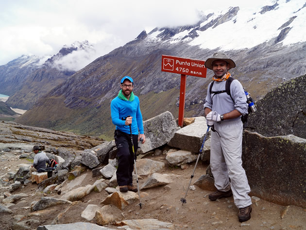
Maximum Altitude: 4750m
Average walking per day: 5 to 6 hours.
Trip notes
When to go
The best season to make this trek is almost all the year, but it is better to make during the Andean summer (April - September). Read more
Clothing and accessories
See the list of recommend gear and equipment list
Description of the trek
The trek is considered as a moderate difficulty, with 3 nights camping in places higher than 3800m, with an average walking per day of 5 to 6 hours, its highest point is Punta Unión 4750m. We strongly recommend to make at least one day acclimatization in places higher to 3800m (short hiking), previous to depart for this trek. If you have more days and you are interested to make some mountaineering activity you can extend the tour to Pisco mountain 5750m, with three additional days you can make the Santa Cruz trek and climb to Pisco mountain.
Trekking permit
The entrance tickets must be bought in advance in Huaraz, in Huascarán National Park's office, or in the ranger station located in Cashapampa village (start point of the trek), it costs S/. 60.00 (around USD 19.00), for 2022 season.
Temperature
During the best trekking season: Mid-April to September, are dry months; the most of the days are sunny, during the day the average temperature is 14 °C and in the nights it drops until 0 °C and in extreme we expect temperature of -5 °C.
Safety
The trek is safe for the permanent presence of visitors, there have been few cases of theft.
Recommended reading
Lonely Planet Trekking in the Central Andes
Peru and Bolivia; The Bradt trekking guide
Note: All the information contained in these pages is intended for guidance only.
Itinerary
Day 1: Huaraz – Cashapampa – Llamacorral
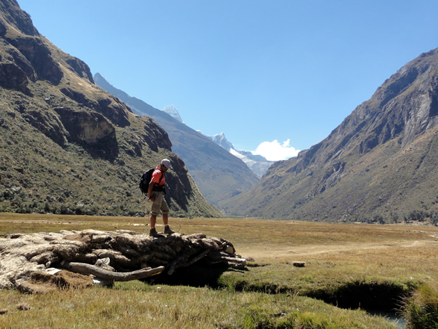
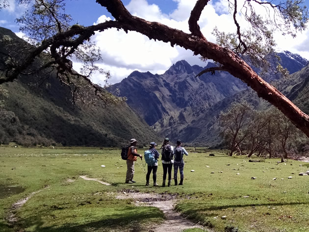
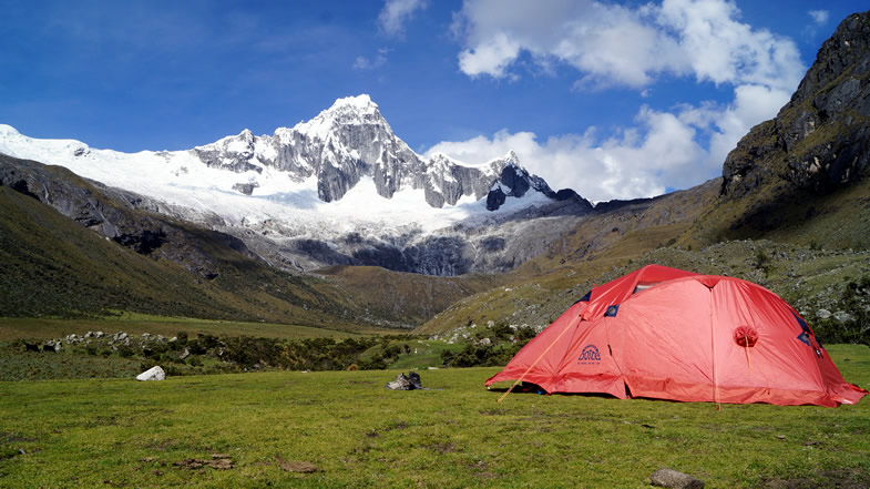
At indicated time pick up in the hotel and we drive to Cashapampa village located at 2900m/ 9 514 ft, getting there take around 3.5 hours; Cashapampa village is the starting point of the trek, place where the Horseman and his pack animals wait for us; from this village we walk up through Santa Cruz valley, the trail follow close to the river among typical Andean trees, after to walk 5 hours we get to Llamacorral campsite 3760m / 12 335 ft, all the time from this place we can see Taulliraju mountain.
Day 2: Llamacorral – Taullipampa
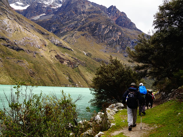
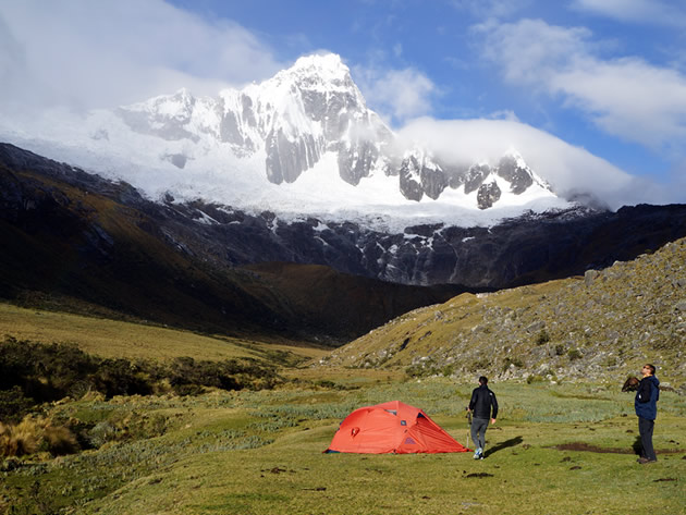
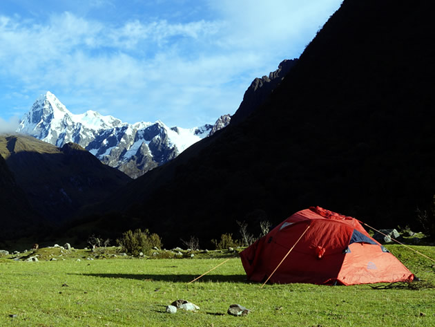
Around 8:00 Am, after the breakfast we start the trekking, this time similar to the previous day we will continue through Santa Cruz valley on the way we visit lakes such as Ichiq cocha and Hatun cocha, (For English: small and big lakes respectively); we see snow-covered peaks like: Caraz, Aguja and Taulliraju, also we observe the Andean flora of this part of the mountain range; we get to Taullipampa 4250 m / 13944 ft, after to walk 4.5 hours approximately, place where we will set up our campsite.
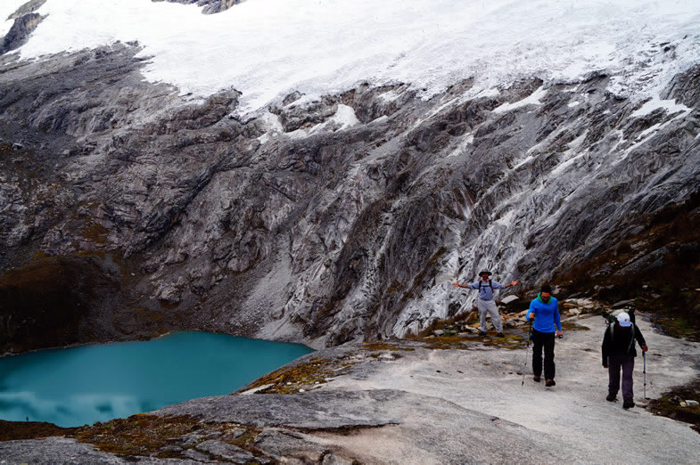
Optional: One one hour close to the campsite we can take a trail to the base camp of Alpamayo mountain, on the way there is viewpoint from there we see the South Face of Alpamayo mountain and Artesonraju peak; after the break we continue to Taullipampa, all this extra visit takes around 2 hours more.
Day 3: Taullipampa – Punta Union pass – Huaripampa valley
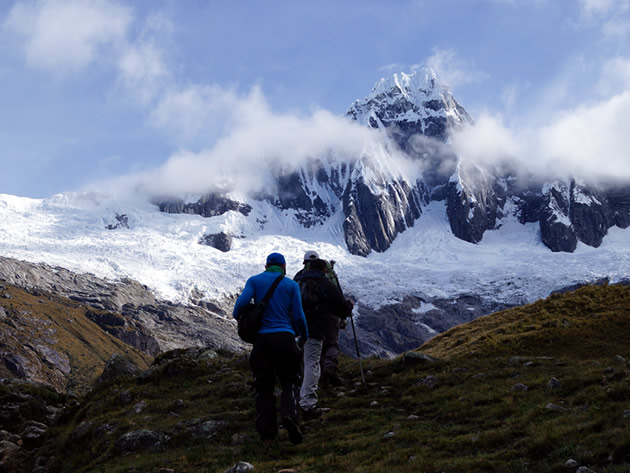
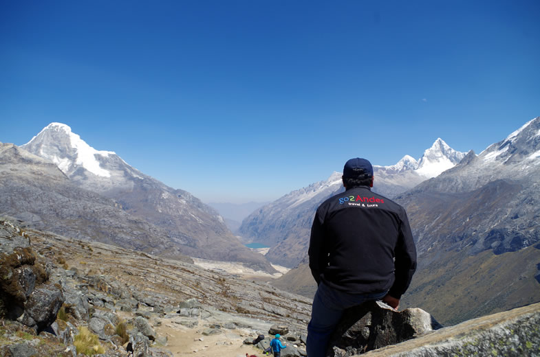
We consider that this day is the most difficult, we go up to Punta Union 4750m / 15584 ft, the highest point of the circuit that we cross walking, place where we get after to walk 3 hours approximately; from this pass we can see very close Taulliraju mountain and others located around it, mountains like: Rinrihirka, Paria, Chacrarjaru, etc. After to take a small break and taken the photos we go down to Huaripampa valley 3850m / 12631 ft, most of the trail of this day follow a rocky path; from the pass to our campsite takes around 3 hours more.
Day 4: Huaripampa – Vaqueria – Huaraz
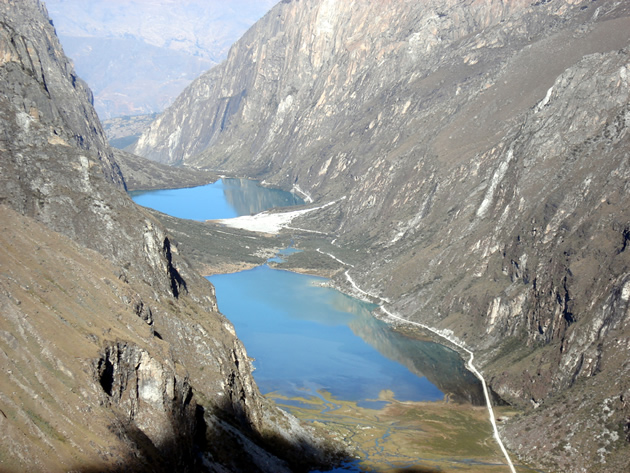
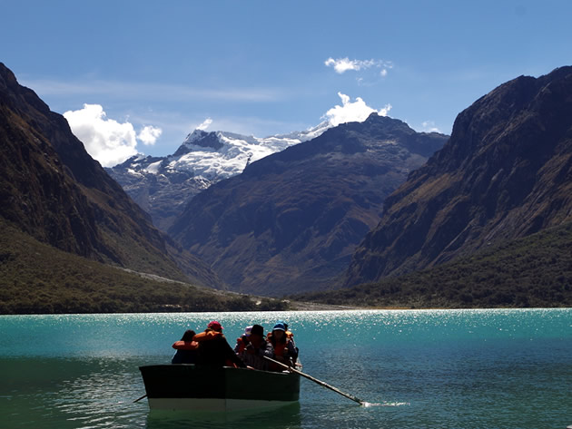
Around 8:00 Am, we start the last day trek, we walk down for around 1.5 hours in Huaripampa valley; then we walk up to Vaqueria village located at 3700m / 12139 ft, this village is the last point of the trek, we get there 2 hours walking; also here a vehicle will wait for us to take us back to Huaraz city; on the way we will stop in Portachuelo pass 4760m / 15 617 ft, from this pass we see the most important peaks of the Cordillera Blanca, peaks like: Chacraraju, Pisco, Huandoy, Chopicalqui and the Peruvian Andes highest peak Huascaran 6768m / 22204 ft; from the pass we go down to the valley and we visit Llanganuco lakes, Orqon cocha and Chinan cocha (for English: male and female lakes respectively), in the afternoon after driving 5 hours we arrive in Huaraz.
Map
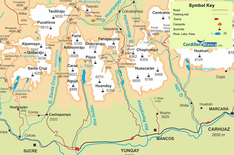
Santa Cruz trek map
Altitude profile
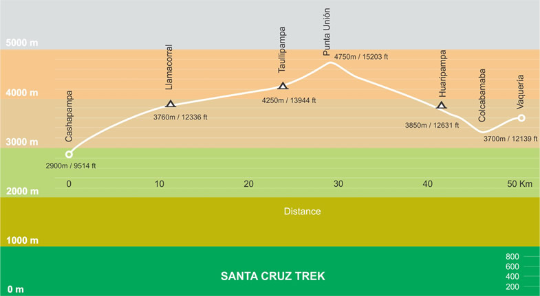
Elevation along Santa Cruz trek
Photo gallery